Nashville is currently home to over 654,000 people. Some individuals live in Nashville's new construction homes in the suburbs, while others make themselves at home in downtown Nashville condos. Regardless of where residents live, they all need to navigate the roadways and drive throughout the city of Nashville to complete their daily routines. For new residents, it can be difficult to know the best ways to navigate through the city. However, this guide is a good starting place for learning the major roadways, typical rush hour, parking situations, and other road rules in Nashville. Read on to learn all about driving in Nashville.
Get to Know Your Major Roads
Nashville is famous for its vast network of highways. Three major interstates all converge at one point by Cumberland River in the downtown Nashville neighborhood. Nashville commuters have mastered the layout of the highways to avoid traffic jams and slowdowns. There are a few Nashville roadways every new resident should know about to ensure the smoothest possible driving experience.
Interstate 24 runs north and south from Chattanooga to the Kentucky state line. The interstate cuts through downtown and is regularly used by residents.
Interstate 40 runs east and west throughout the entire state. It forms a major interchange with I-24 and I-65 in the center of the city. It also features auxiliary I-440 to help residents avoid downtown traffic.
Interstate 65 also runs north and south through the East Nashville area, connecting drivers with major downtown roadways like Charlotte Pike, 4th Avenue North, Demonbreun Street, and Broadway. While driving downtown, all drivers should be vigilant. The city has two-way bike lanes that flow with vehicle traffic.
The roadways may not sound confusing, but the interchanges can make it difficult to navigate at first. For example, following I-24 west points both north and east. Those who want to drive south on I-65 to reach the heart of Nashville will need to know that they need to take I-40 east to continue heading south into the city. Everyone gets lost at least once, so there's no need to worry. An in-car GPS or a conversation with a convenience store clerk can always point drivers in the right direction.
What to Expect During Rush Hour
 Nashville does not have a pleasant rush hour, but it's not as bad as the worst traffic indexes in the country. Monday through Friday, drivers can expect to encounter traffic jams between 7 a.m. to 9 a.m. and 4 p.m. to 6 p.m. Those who carpool may want to use the high-occupancy vehicle (HOV) lanes during rush hour. These lanes are typically open and allow traffic to flow more freely.
The average commute in Nashville is on par with the nation's average at around 25 minutes each way. Nearly 80% of residents drive their own vehicle, which is why congestion can be expected every weekday morning and evening. Only 10% of drivers carpool, and these drivers take full advantage of the HOV lanes.
At this time, about 2% of Nashville residents use public transportation. This is another contributing factor to congestion during rush hour. Additionally, only 5.6% of residents work from their homes. These individuals do not need to commute into the city during rush hour, which means just over 32,000 residents do not need to be part of the typical morning or evening rush during the workweek.
Nashville Drive Times
Knowing ahead of time how long it might take you to drive from one place to another is always helpful. Here are images for estimated drive times from downtown Nashville, the International Nashville Airport, and the Brentwood community.
These are the approximate drive time zones based on leaving downtown Nashville and the lines represent the distance covered for 15 mins, 30 mins, 45 mins and 60 minutes.
Red = 15 minutes * Blue = 30 minutes *
Green = 45 minutes * Brown = 60 minutes *
Downtown Nashville Drive Times
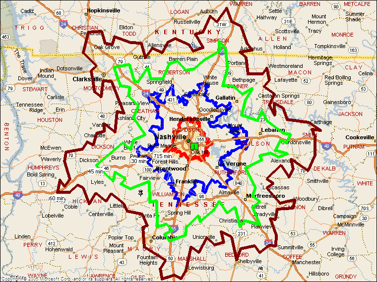 These are the approximate drive time zones based on leaving downtown Nashville. The lines represent the distance covered for 15 minutes, 30 minutes, 45 minutes, and 60 minutes. Cities like the Hendersonville community and the Franklin community are within the 30-minute commute, but it could take more time to reach places like the Gallatin community.
International Nashville Airport Drive Times
 The inner blue line shows the distance a car can drive leaving the airport after 15 minutes of driving. The outer blue line shows the extent of the 30 minute travel time. Henderson and Brentwood are within the 30-minute radius, though other cities like Gallatin and Franklin are longer commutes.
Brentwood Drive Times
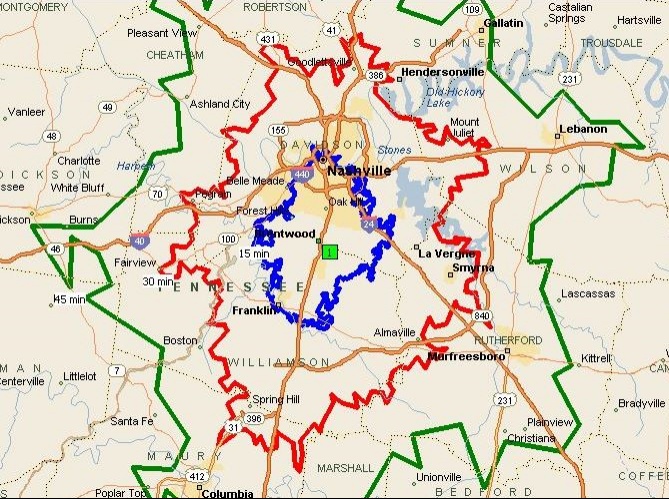 The blue line represents 15 minutes drive from Brentwood, the red line 30 minutes and the green line is 45 minutes. Downtown Nashville is within the 15-minute radius, while cities like Hendersonville and the Gallatin are past the 30-minute commute.
Parking in Nashville
When it comes to parking in Nashville, the city has made it incredibly easy for residents and tourists alike. With the city's Park It Downtown website, every user can utilize the interactive map. Whether one needs to find an electric-car charging station or wants to find a specific type of parking (a lot, garage, street, etc.), they can easily do so by using the website's filter. There are several parking options near the most popular attractions in the city. The website allows users to easily scout out these spots before they arrive in Nashville. Additionally, numerous $5 and $10 parking deals can be found during specific events.
Street parking is available in most of the popular neighborhoods in Nashville. Over 1,000 metered spaces are available at inexpensive rates. To park for 20 minutes, the rate is only $0.50. Metered spots are timed for only up to two hours, and parking enforcement will issue tickets to those who have let their meters expire.
Meters for on-street parking are strictly enforced Monday through Saturday from 8 a.m. to 6 p.m. Outside of those times and all day on Sunday, street parking is completely free. Additionally, street parking is free on New Year's Day, July 4th, Labor Day, Thanksgiving, and Christmas Day.
Driving Laws in Tennessee
Fortunately, driving in Nashville is fairly simple. However, the city does have a few rules that may differ from other larger cities. First, the HOV lanes are available for use Monday through Friday from 7 a.m. to 9 p.m. on inbound lanes and from 4 p.m. to 6 p.m. on outbound lanes. During those times, only vehicles containing two or more individuals may utilize the HOV lanes. Outside of those times, any vehicle may use the HOV lane.
According to Tennessee's Hand's Free Driving Law, no cell phones are permitted to be held while driving. If caught, drivers can expect a minimum of a $200 fine for their first offense. Dashboard mounts, headphones, Bluetooth devices, and smartwatches may be utilized while driving.
Nashville Driving Etiquette
The items listed below are some tips for good driving etiquette in Nashville. Although unofficial and unwritten, these guidelines help reduce traffic congestion when driving on Nashville highways and side roads.
- Do not stop on the interstate without good reason. Sudden speed changes can cause congestion or even an accident as cars adjust to your speed.
- Speed limit signs are placed everywhere, reminding everyone to follow the minimum and maximum speeds to travel.
- Center lanes are only meant for slowing down to make a left turn. It should never be used for passing because traffic can go in from both directions and create a dangerous potential for head-on collisions.
- Use your turn signal if you intend to turn or change lanes.
- Make sure your brake lights are functioning.
- Solid lines in the road are there to indicate that you cannot cross them for passing. The right solid line is the right border of the road. Dotted lines indicate a legal passing location, but only if the conditions are right.
- It's not a good idea to pass on the shoulder even if you are in a hurry.
- High-occupancy vehicle lanes are meant for two or more occupants in a vehicle.
- A responsible semi-truck driver usually provides extra space between their vehicle and yours. Return the favor by leaving this space open so that the semi-truck has plenty of space to brake.
- Lastly, driving in the left lane is only okay if there's congestion or if you're using the lane for passing. This is especially important on two-lane roads.
How Do Cities Reduce Congestion?
Nashville has made many efforts to reduce congestion and improve traffic conditions, but there are always more methods to consider. Other cities have turned to ideas like rewarding workers who choose to carpool to reduce the sheer number of cars on the road during rush hour. Adaptive traffic signals that change the length of stop and go signals based on traffic levels can also go a long way in reducing gridlock and preventing accidents that further snarl up the flow.
These traffic lights tend to work in conjunction with a system known as Inbound Flow Control (IFC). An IFC system measures how much traffic is currently in a city and how much is incoming, then balances the number of cars heading into the city with the number existing. Increasing public transportation options like buses and making it safer to use alternative transport like bikes are two techniques that go hand in hand to reduce congestion.
Drive Times From Your Nashville Home
The starting point for most people when they know they are moving to Nashville and they start looking for a home is to base the actual area to search on the drive time from their place of work. The Ashton Real Estate Group Realtors can help you with this by creating a personal drive time map based on the office location or even the location of a preferred school. This can really help you narrow down the areas you should be researching.
Get Out and About in Nashville
Driving in Nashville is similar to driving anywhere else in the nation. Even with the tricky interchanges, navigating the city can become familiar with practice. After a few weeks, any new resident can quickly become knowledgeable of the local traffic flow and enjoy easy access to all of the fun things to do in Nashville. As with any big city, some congestion is to be expected. However, it's a small price to pay to enjoy the vibrant culture and excellent amenities of Music City.
If the opportunities of Nashville excite you, contact The Ashton Real Estate Group of RE/MAX Advantage with Nashville's MLS at (615) 603-3602 to get in touch with local real estate agents who can help find the perfect Nashville home for you today.
Read Our Driving Guides For Each City Below